Name
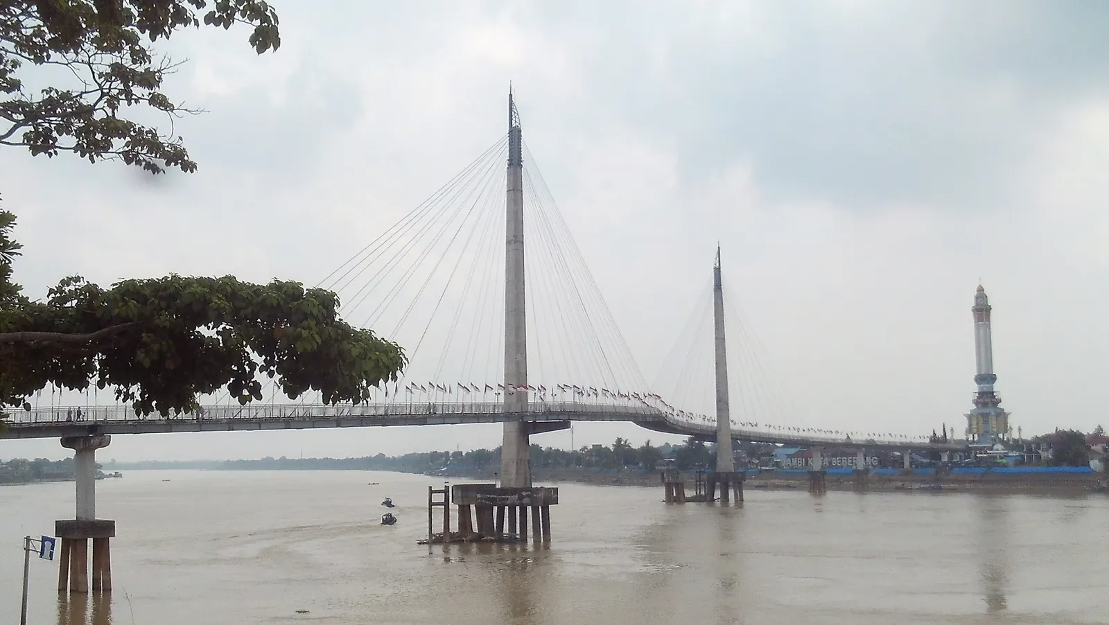
Jambi City · Batanghari River Pedestrian bridge & city landmark
Cross with context, not just from one bank to another.
Jembatan Gentala Arasy connects the Batanghari riverfront with Jambi Kota Seberang. This guide reads the bridge as a walking route, a river viewpoint, and a doorway to the cultural heritage around it.
Documentary photo: Firzafp · CC BY-SA 4.0
An independent guide, not an official notice.
We assemble this page from public sources and do not sell tickets, tours, or commercial recommendations. Opening times, access, facilities, and riverfront conditions can change; check conditions on site before travelling.
ORIENTATION
Six markers for reading the place.
Before arriving, separate changeable visitor data from more stable context. It is a useful way to set realistic expectations.
Address
Jl. Raden Pamuk, Kasang
Jambi Timur District · Jambi City 36123Coordinates
-1.5866286, 103.6157117
Google Maps location referenceInaugurated
28 March 2015
According to a Jambi Provincial Government publicationForm
S-shaped curve
For pedestriansMap status when read
Open · closes 12 AM
Google Maps status; may changeRIVER & CITY CONTEXT
A bridge that traces the Batanghari River.
Gentala Arasy matters for more than its span. It brings together everyday movement, a river panorama, and a cultural landscape anchored by Menara Gentala Arasy on the opposite side.
Sources[1] [2] [3]
Two banks, one walk
This pedestrian bridge joins access near Menara Gentala Arasy in Jambi Kota Seberang to the Pasar Jambi riverfront. At around 4.5 metres wide and 503 metres long, it is both a crossing and a place to look outward.[1]
Tower and cultural memory
At one end, Menara / Museum Gentala Arasy offers an important setting for learning about Islamic history and civilisation in Jambi. The museum is positioned as a cultural learning space, not merely a photo backdrop.[2]
A name carrying an idea
A provincial cultural source explains the Gentala Arasy name through ideas of sound, harmony, and an orientation toward the sky. Some accounts also link it to an honouring of Abdurrahman Sayoeti.[3]
An active riverfront
The river is a living corridor, not scenery alone. Use the designated path, keep clear of the river edge, and make space for residents using the public realm.
HISTORY & INTERPRETATION
From a riverfront project to a place for cultural learning.
This guide separates documented construction facts from interpretations of the name and stories that need careful reading. Not every popular account has enough sourcing to be treated as history.
- 01
Kota Seberang as context
Menara / Museum Gentala Arasy sits in Jambi Kota Seberang, an area described by Indonesia.travel as important to the history of Islamic education and civilisation in Jambi.[2]
- 02
2012–2014: construction period
Jambi Provincial Government records the pedestrian bridge as a project built across the 2012–2014 budget years. This explains its development timeline, not a guarantee about today’s facilities.[1]
- 03
28 March 2015: inauguration
The provincial-government and national-tourism sources both place the complex’s inauguration on 28 March 2015. The bridge can then be read as a physical connection between riverbank and cultural space.[1][2]
- 04
A name with documented readings
Cultural sources explain Gentala Arasy through genta, tala, and arasy; the same source also records an acronym connected to Abdurrahman Sayoeti. Present these as documented interpretations, not a single uncontested folk legend.[3]
- 05
A responsible story
We did not find a public source strong enough to present a particular local legend as verified bridge history. This guide therefore prefers traceable context over repeating unsupported stories.
- 06
Batanghari in Jambi's history
The Batanghari River is a source of Jambi's settlement and trade history; cultural sources place Jambi Kota Seberang within the region's Islamic-civilisation history.[2] The bridge joins two banks historically linked by the river.
- 07
Reading critically
Names and stories around the bridge keep growing in public space. We present what can be traced to sources, and invite you to re-verify through official references before trusting any particular narrative.
VISIT PLAN
Arrive at the right pace.
The bridge works best as a slow walk. Allow room to pause at safe points and adapt the plan to weather and crowd levels.
Best time
Morning or late afternoon
The light is softer and heat exposure is usually easier to manage. Do not push on through heavy rain or extreme heat.Duration
45–90 minutes
Enough time to cross slowly, observe the river, and connect the walk with Menara Gentala Arasy.Cost
No fixed charge verified
We have not verified a bridge-entry ticket in public sources. Check current local signs or staff for services that may change.Etiquette
A pedestrian route
Keep the walkway moving, do not climb railings, and do not leave litter. Give space to residents using either riverbank.DETAILED TRANSPORT
Reach the Jl. Raden Pamuk or Jambi Kota Seberang side.
Choose an entry side that fits your itinerary. Google Maps places Jembatan Gentala Arasy at Jl. Raden Pamuk; a provincial cultural source also identifies access from the Menara Gentala Arasy side via Jl. KH. M. Ja'afar.[3][6] Routes, drop-off points, schedules, and parking capacity are visit-day information—not permanent promises from this page.
- 01
From Sultan Thaha Airport (DJB)
From the airport terminal, continue by licensed taxi, hired vehicle, or ride-hailing service to one bridge approach. Give the driver a clear destination—Jl. Raden Pamuk or the Menara Gentala Arasy side—and confirm a safe drop-off point before leaving.
- 02
Bus / public transport
Jambi City has mass-transit services and public-transport data, but routes, timetables, active stops, and the final connection to the bridge can change. Check Jambi City Transportation Department channels or a live map on the day, and allow for a walk or short onward connection from an active stop.
- 03
Taxi & ride-hailing
For a first visit, this is usually the most direct option. Enter “Jembatan Gentala Arasy” or the Jl. Raden Pamuk address, then state which side you intend to start from. Arrange a return pick-up before walking far so you are not dependent on momentary availability.
- 04
Car or motorcycle
Use current city roads and clearly permitted parking only. Do not stop at the bridge approach, in a traffic lane, or anywhere that obstructs movement. Capacity can change on weekends, during worship, or around public events.
- 05
Walking & cycling
From central-city areas, the riverfront can form part of the journey. Watch road crossings, uneven surfaces, rain, midday heat, and traffic. Do not take a bicycle onto the pedestrian route when signage or local conditions do not allow it.
- 06
Choosing an approach side
The Jl. Raden Pamuk side suits an onward journey through central-city services; the Menara Gentala Arasy side suits a visit linked to the museum and Jambi Kota Seberang. They can be read as one route, but plan the return journey before you start.[3]
FACILITIES & PRACTICAL NEEDS
The small details worth planning.
We do not recommend individual vendors, hotels, transport operators, or charging sites. This list describes needs that may arise; availability, quality, price, and accessibility should be assessed by you on the day.
Plan ahead
WC / toilets
Availability at the visitor point can change. Use clearly authorised public facilities before starting if needed; do not assume a toilet is available at the bridge entrance.Check on arrival
Parking
Do not expect a space at the bridge approach. Follow signs, staff direction, and local rules; choose legal parking even if it means a slightly longer walk.Assess real conditions
Access & mobility
An open route does not automatically mean full accessibility. Check gradients, surface condition, crowds, rest points, and vehicle access before bringing children, a stroller, or mobility aids.Bring personal protection
Shade & rest
Heat, rain, and seating conditions vary along the route. Carry water, a hat or umbrella, and do not stop in narrow pedestrian areas.Choose a type, not a name
Food & drink
The riverfront and city area may have food stalls, restaurants, drink counters, and snack kiosks. Assess hygiene, dietary needs, and clear pricing on site.Search across the city
Accommodation
Jambi City has guesthouse, hotel, and short-stay accommodation types. Compare transport access, accessibility, and late-evening return options; closeness on a map is not always a comfortable walk.Carry basics
Daily essentials
General stores, markets, and convenience shops can be found across the city. Carry water and personal necessities for a longer walk instead of depending on one service point.Check before driving
Fuel & charging
Use a current map to locate active fuel stations or electric-vehicle charging points on your route. We do not verify connector availability, opening hours, or queues.Take it with you if needed
Waste & cleanliness
Use available bins. If none are present, carry waste until you reach suitable disposal so the riverbank and pedestrian route remain clean.TODAY'S WEATHER
Weather at the Batanghari riverfront.
Live weather and a multi-day outlook to help you choose when to cross. Recheck before you leave.
SEASONAL STRATEGY
Reading Jambi's climate pattern.
Jambi has an equatorial climate with two rainfall peaks (around March–May and October–January) and a drier period (June–September). The guide below is general, based on local climate patterns rather than daily data; verify current weather before travelling.
| Period | Weather & rainfall | Riverfront & water | Nature & wildlife | Visit suggestion | What to bring |
|---|---|---|---|---|---|
| Jun–Sep Drier | Lower rainfall; strong midday heat. | Relatively calm flow, easier to read. | Birds & riverfront activity stand out morning/evening; wildlife more visible when calm. | Comfortable for slow walks & soft-light photos. | Water, hat, sunscreen, breathable clothing. |
| Mar–May & Oct–Jan Wetter | More frequent rain; path may be slippery. | Higher discharge, stronger current—keep clear of the edge. | Greener riverbank; wildlife more active after rain. | Avoid crossing in heavy rain; check the daily forecast. | Umbrella/rain jacket, slip-resistant shoes. |
| Transition Feb, Jun, Sep | Mixed weather, can change fast. | Depends on recent rainfall. | Watch today's conditions. | Plan a flexible route & time buffer. | Dual protection (heat & rain). |
The Batanghari is a living river with boat traffic and fish and bird ecosystems. Do not swim or drink river water, and keep a safe distance from the edge when discharge is high.
RECOMMENDED ROUTES
Two options by available time.
Both start and return from the same side unless noted. Match them with the two approach sides in Transport.
Quick crossing + riverfront
Drop off at the Jl. Raden Pamuk side → cross one way → pause mid-span for photos → return to the starting side → continue to Tepian Tanggo Rajo for a riverfront rest. Good for families with children or a short stop.
Crossing + heritage + city
Start at Menara / Museum Gentala Arasy (Jambi Kota Seberang) → cross the bridge → Pasar Jambi riverfront → lunch in the city area (choose a type of place, not a name) → Tepian Tanggo Rajo → return to the tower side in the late-afternoon light. Include rest time & check the weather.
GROUP ITINERARIES
Three approaches by who is coming.
Choose by trip composition and pace, not only by duration.
Families with children
Short & safe
Choose the morning; carry water & hat; use sections with rest space; avoid the hot hours; stay near public facilities; do not let children near the river edge.Nature photographers
Soft light
Best light is morning/late afternoon for tower silhouettes & river reflections; bring wide & tele lenses; use the three documented angles; check the cloud forecast.Low-effort access
Slow & guided
Come with a companion; assess gradients & crowds in person; pick the easiest approach side; plan a nearby pick-up; rest regularly.First-time visitors
Unite the two banks
Start at the tower side for cultural context, cross to the Pasar Jambi side, then return; treat it as one complete route rather than just crossing.FOOD NEARBY
Choose a type of place, not a promoted business.
For a meal before or after the crossing, Jambi City offers local food stalls, restaurants, coffee shops, drink kiosks, and market areas. We do not rank or name businesses; choose according to hygiene, family needs, and clear pricing shown on site.
AROUND THE BRIDGE
Build a river-cultural corridor into the visit.
Menara / Museum Gentala Arasy
Near one bridge end; an entry point for the history of Islam and culture in Jambi. Check museum access on the day you visit.[2]
Tepian Tanggo Rajo
A riverfront public space useful for extending a walk and seeing the city’s relationship to the Batanghari. Respect how residents use the area.
The Jl. Raden Pamuk side
This side connects naturally with central-city services and your onward journey. Use a live map to choose the most suitable route.
LOCATION
A map and two approach sides.
The embedded map is set to Bahasa Indonesia. For navigation, open Google Maps and choose the entrance side that fits your route.
Open directions in Google MapsVISUAL DOCUMENTATION
Three angles for reading the bridge’s scale.
Photos on this page are real, openly licensed documentation—not generated illustration. Every image is credited and carries its licence in the caption.
River edgeA view of the bridge, river, and Menara Gentala Arasy.
Photo: Firzafp · CC BY-SA 4.0 ↗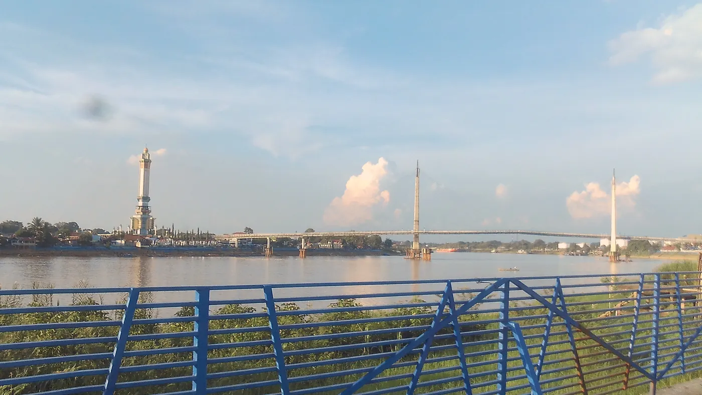
From the riverfront parkRiver space, bridge line, and tower in a single view.
Photo: Firzafp · CC BY-SA 4.0 ↗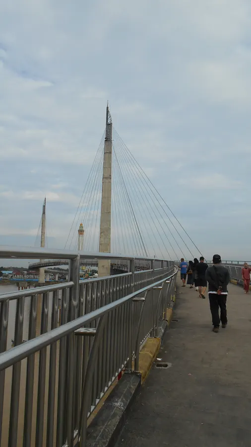
On the bridgeThe actual scale of the pedestrian route and its approach toward the pylons.
Photo: Firzafp · CC BY-SA 4.0 ↗FAQ
Practical questions before you cross.
01Is Jembatan Gentala Arasy for pedestrians?+
Yes. Public sources describe it as a pedestrian bridge; continue to follow current signs and instructions when you arrive.[1][3]
02When is a comfortable time to visit?+
Morning or late afternoon are usually more comfortable for walking and lower heat exposure. Weather and crowd conditions still matter on the day.
03Is there an entry fee?+
We have not verified a fixed fee for crossing from public sources. Do not assume older information is still current; check signs on site.
04How long should I allow?+
Around 45–90 minutes is reasonable for a slow crossing and safe pauses; add time if you include Menara / Museum Gentala Arasy.
05How do I come from the airport?+
From Sultan Thaha Airport (DJB), continue by taxi, hired car, or ride-hailing service to the Jl. Raden Pamuk approach or the tower side. Confirm a safe drop-off point.
06Are parking and toilets available?+
Both should be checked on the day. Use authorised parking and plan toilet needs before entering the pedestrian route; this page does not guarantee availability at a particular point.
07Is the bridge wheelchair friendly?+
It is an open walking route, but approach conditions, slopes, crowds, and supporting facilities need to be assessed in person. Travel with a companion if you need mobility assistance.
08Is it safe to visit after dark?+
Light, crowds, weather, and return transport change with the time of day. If you arrive near evening, use a route you know, plan a pick-up point, and follow local direction.
09Does this site recommend restaurants, hotels, or shops?+
No. As a non-profit guide, we explain service types and ways to assess practical needs. We do not rank businesses, accept promotion, or recommend particular operators.
SCIENCE & RESPONSIBILITY
Reading the bridge as a learning space.
This site is educational: read the bridge as infrastructure, a river space, and a cultural doorway—not merely a crossing.
Why the S shape
Responding to the river
The curved span follows the Batanghari's flow and current; it is a light civil-engineering note anyone can read while on the bridge.River as corridor
Settlement history
The Batanghari shapes Jambi's trade and settlement history; the bridge brings together two banks long separated by the river.Jambi's Islamic heritage
A learning space
Menara / Museum Gentala Arasy holds a thread of civilisation; visit it as a place of learning, not just a photo backdrop.Visitor responsibility
Keep it together
Bin your rubbish, respect how residents use the space, do not climb railings, keep clear of the edge, and lighten your footprint when busy.HOW WE HANDLE INFORMATION
A guide that separates facts, visit-day conditions, and personal choices.
A professional destination page does more than add information: it also explains the certainty limits of that information. This framework helps readers use the guide critically and independently.
Relatively stable facts
Bridge dimensions, the two approach sides, the construction period, and museum context are tied to government or cultural-institution sources.[1][2][3]
Visit-day conditions
Hours, bus services, pick-up points, toilets, parking, weather, and riverfront conditions can change. Verify them through on-site signage, official channels, or a live map.
Neutral about businesses
We do not list business names, ratings, affiliate links, prices, or promotions for restaurants, hotels, shops, drivers, fuel stations, or charging services.
Continuous improvement
If information appears wrong or has changed, use the named public sources to check it again before sharing it onward.
PUBLIC SOURCES
Read further from open public sources.
We prioritise government, public tourism, and cultural-institution sources. Map data is dynamic; use it for trip planning rather than as a service guarantee.
01
Regional governmentJambi Provincial Government — Jambi City profile
↗02National tourismIndonesia.travel — Museum Menara Gentala Arasy
↗03Culture & archivesJambi Provincial Archives and Museum Agency — Gentala Arasy
↗04City dataKota Jambi Satu — Gentala Arasy virtual 360°
↗05City transportJambi City Transportation Department
↗06Location dataGoogle Maps — Jembatan Gentala Arasy
↗